otomatis

Showing posts with label jalan-jalan. Show all posts

jalan-jalan kuta square


Kuta District (Indonesian:Kecamatan Kuta) covers subdistricts/villages (Indonesian:Kelurahan/Desa) of Kuta Village, Legian, Seminyak, Kedonganan, and Tuban. Furthermore Badung Regency has 3 districts with the name Kuta: Kuta, Kuta South District Kecamatan Kuta Selatan (Jimbaran and the whole Nusa Dua peninsula), and Kuta North District Kecamatan Kuta Utara (villages of Kerobokan Klod, Kerobokan, Kerobokan Kaja, Tibu Beneng, Canggu and Dalung).
Kuta is now

jalan-jalan ke pantai kuta

take walking on kuta


Kuta is administratively a district (kecamatan) and subdistrict/village (kelurahan) in southern Bali, Indonesia. A former fishing village, it was one of the first towns on Bali to see substantial tourist development, and as a beach resort remains one of Indonesia's major tourist destinations. This tourism known internationally for its long sandy beach, varied accommodation,
--> many restaurants and

National Monument (Indonesia-part2)

Monument design


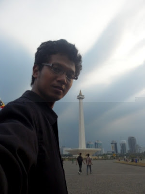
The towering monument encapsulates the philosophy of Lingga and Yoni. Lingga resembles an alu rice pestle and Yoni resembles a lesung rice mortar, two important traditional Indonesian tools. Lingga and Yoni also symbolize eternal life with the lingga phallic symbol, representing masculinity, positive elements, and daytime and the Yoni the female organs symbol, representing femininity, negative elements, and night. The monument consists of a 117.7m obelisk on a 45m square platform at a height of 17m, the goblet yard. The obelisk itself is clad with Italian marble.
The northern pond measuring 25×25 m was designed to cool water for the air conditioning system in the monument as well as to enhance the beauty of the surrounding area. To the north of the monument, there is a statue of Indonesia national hero Prince Diponegoro by Italian sculptor Cobertaldo. The entrance to the monument is located at the Medan Merdeka Utara or Northern Merdeka Park, through the

National Monument (Indonesia-part1)

"Monas" redirects here. In scientific nomenclature, -monas (meaning "unicellular") is a suffix for bacterial genera or Monas (genus), a protist.6°10′31.45″S 106°49′37.61″E

The National Monument (Indonesian: Monumen Nasional (Monas)) is a 433 ft (132 metre) tower in the centre of Merdeka Square, Central Jakarta, symbolizing the fight for Indonesia's independence. Construction began in 1961 under the direction of President Sukarno and the monument was opened to the public in 1975. It is topped by a flame covered with gold foil. The monument and the museum is open daily from 08.00 - 15.00 Western Indonesia Time (UTC+7), everyday throughout the week, except for the last Monday of each month, when the monument is closed.
Background


A letter expressing Sukarno's wish for the construction of a "National Column" dated 29 July 1963
After the Indonesian government returned to Jakarta from Yogyakarta in 1950 following the Dutch recognition of Indonesian independence, President Sukarno began to contemplate the construction of a national monument comparable to the Eiffel Tower on the square in front of the Presidential Palace. On 17 August 1954, a National Monument Committee was established and a design competition was held in 1955. This attracted 51 entries, but only one design, by Frederich
--> Silaban, met any of the criteria determined by the committee, which included reflecting the character of Indonesia in a building capable of lasting for centuries. A repeat competition was held in 1960, but once again, none of the 136 entries met the criteria. The chairman of the jury team then asked Silaban to show his design to Sukarno. However, Sukarno did not like the design as he wanted the monument to be in the form of a linga and yoni. Silaban was asked to design such a monument, but his design was for a monument so large that it would have been unaffordable given the economic conditions at the time. Silaban refused to design a

bercanda di pantai molang

Sebenarnya, Tulungagung memiliki banyak potensi pariwisata yang bisa diandalkan sebagai salah satu sumber pendapatan daerah. Sayangnya, masih banyak potensi pariwisata yang belum digarap secara baik oleh Pemerintah Kabupaten Tulungagung. Meski demikian, industri pariwisata di Tulungagung cukup berkembang dengan objek wisata andalan Pantai

Krakatoa (Indonesian: Krakatau) part 2


In February 1780, the crews of HMS Resolution and HMS Discovery, on the way home after Captain James Cook's death in Hawaiʻi, stopped for a few days on Krakatoa. They found two springs on the island, one fresh water and the other hot. They described the natives who then lived on the island as "friendly" and made several sketches. (In his journal, John Ledyard calls the island "Cocoterra".)
--> Dutch activityIn 1620 the Dutch set up a naval station on the islands and somewhat later a shipyard was built. Sometime in the late 17th century an attempt was made to establish a pepper plantation on Krakatoa but the islands were generally ignored by Dutch colonial authorities. In 1809 a penal colony was established at an unspecified location which was in operation for about a decade. By the 1880s the islands were without permanent inhabitants; the nearest settlement was the nearby island of Sebesi (about 12 km away) with a population of about

Krakatoa (Indonesian: Krakatau),


In February 1780, the crews of HMS Resolution and HMS Discovery, on the way home after Captain James Cook's death in Hawaiʻi, stopped for a few days on Krakatoa. They found two springs on the island, one fresh water and the other hot. They described the natives who then lived on the island as "friendly" and made several sketches. (In his journal, John Ledyard calls the island "Cocoterra".)
--> Dutch activityIn 1620 the Dutch set up a naval station on the islands and somewhat later a shipyard was built. Sometime in the late 17th century an attempt was made to establish a pepper plantation on Krakatoa but the islands were generally ignored by Dutch colonial authorities. In 1809 a penal colony was established at an unspecified location which was in operation for about a decade. By the 1880s the islands were without permanent inhabitants; the nearest settlement was the nearby island of Sebesi (about 12 km away) with a population of about

history of kelud mountain

Kelud is a volcano mountain located in East Java on Java in Indonesia. Like many Indonesian volcanoes and others on the Pacific Ring of Fire, Kelud is known for large explosive eruptions throughout its history. More than 30 eruptions have occurred since 1000 A.D. this mountain has erupted many times. On May 19, 1919, an eruption at Kelud killed an estimated 5,000 people, mostly through hot mudflows (also known as "lahar"). More recent eruptions in 1951, 1966, and 1990 have altogether killed another 250 people.


Kelud (Klut, Cloot, Kloet, Kloete, Keloed or Kelut) is a volcano located in East Java on Java in Indonesia. Like many Indonesian volcanoes and others on the Pacific Ring of Fire, Kelud is known for large explosive eruptions throughout its history. More than 30 eruptions have occurred since 1000 AD.

On May 19, 1919, an eruption at Kelud killed an estimated 5,000 people, mostly through hot mudflows (also known as "lahars"). More recent eruptions in 1951, 1966, and

mendaki gunung kawi (part 3-habis)

Meski hujan dengan derasnya dan angin menyerang dengan kencangnya, akhirnya kami memutuskan untuk turun gunung. Dengan pertimbangan bahwa bekal kami sudah habis. Jika kami tetap bertahan maka kami akan kelaparan dan bukan tidak mungkin terjebak lapar di hutan sehingga kami mati kedinginan. Bergegas kami mem-packing semua perbekalan. Dan kami turun dengan kondisi agak tergesa karena keburu malam yang akan menyulitkan perjalanan karena banyaknya jurang. dalam perjalanan, saya berjalan dengan zazun yang membawa barangcukup berat sehingga kami pada posisi paling belakang. Kami turun gunung ditemani hujan yang cukup deras. Baru setelah melewati pos 4 kami baru bisa melihat awan putih dengan indahnya. Seperti ini gambarnya.


Sambil terus berjalan kami berdoa agar cuaca semakin cerah, namun kehendak alam tidak demikian. Hari semakin petang. Jam sudah menunjukkan lebih dari pukul 5 sore. Sementara saya, zazun dan fuad tertinggal jauh dari kawan-kawan yang entah sudah sampai mana. Kami bertiga terpisah dari tim. Hari semakin gelap. Senter tak ada, hanya senter dari korek api 2000 ribu-an yang kami punya. Cukup riskan untuk meneruskan perjalanan. Untungya kami menemukan pos 2 sehingga kami bisa membangun tenda di sana. Meski tanpa air. Kami mengandalkakan air hujan. Hanya itu yang bisa kami nikmati. Ada yang lucu di sini, setelah puas menenggak air separuh cangkir untuk bertiga. Kami melihat isi air, termyata isinya ada

Mendaki Gunung Kawi (part1)


Gunung kawi adalah sebuah gunung berapi di Jawa Timur, Indonesia, dekat dengan Gunung Butak. Tidak ada catatan sejarah mengenai letusan gunung berapi ini.
Gunung Kawi, terletak di sebelah barat kota Malang merupakan obyek wisata yang perlu untuk dikunjungi bila kita berada di Jawa Timur karena keunikannya, obyek wisata ini lebih tepat dijuluki sebagai "kota di pegunungan". Di sini kita tidak akan menemukan suasana gunung yang sepi, tapi justru

mendaki gunung kawi (part 2)

Kami mencoba mendaki gunung kawi meski terkena cukup angker, toh kami punya pemandu yang cukup handal salah satu kawan ku. Zazun namanya. Kami packing dan persiapan di kampus berangkat dengan APV kampus di antar bapak Hery dosen kemahasiswaan kami. Kami berangkat pagi. Sampai di gerbang kawisari kami harus istirahat berjalan hingga perkebunan teh senggrong. Disanalah kami mempersiapkan segalanya sebelum melangkah memuncak. Kami berangkat cukup sore, sehingga memaksa kami untuk membangun tenda di pos 1. Selain gelap, hujan deras juga mengguyur kami sehingga memaksa malam itu kami berkemah. Pagi2 kami bergegas untuk melanjutkan perjalanan, namun hari keburu sore sehingga kembali lagi kami tak bisa mencapai puncak dan harus puas di pos ke 5. Selain hujan yang cukup deras, badai gunung juga mengahajar kami. Kami akan memuncak esok hari.


Pagi hari cuaca cukup tenang meski kabut tak dapat menghilang. Tenda kami biarkan tetap di pos 5, tim di bagi 2. Ada yang memuncak sambil mencari air, ada yang tunggu tenda. Karena saya belum pernah mencapai puncak, saya memilih untuk ikut ke puncak bersama beberapa kawan yang lain. Seperti halnya di pos 5, kabut tebal dan angin kencang namun dengan kualitas lebih besar menerpa kami. Dingin sekali di puncak kawi, sayang cuaca hari itu berkabut tebal sekali sehingga sulit untuk menikmati panorama gunung kawi. Seperti ini

Senangnya Outbond di Pantai Serang


Sekilas
Pantai Serang merupakan sebuah pantai yang berada di desa Serang kecamatan Panggungrejo kabupaten Blitar propinsi Jawa Timur. Terletak kurang lebih 45 km di arah barat daya kota Blitar.
Setiap bulan Suro, diadakan upacara di pantai ini. Pantai ini juga sering digunakan untuk memperkirakan bulan Ramadhan dan menentukan hari Raya Idul Fitri.
--> Pantai Serang merupakan pantai alam yang indah. Terbentang pasir putih sepanjang pantainya. Pengunjung dapat melakukan banyak kegiatan di pantai ini seperti

kuta beach bali-surfer heaven


helow indonesian tourism core lovers. Kuta is the most famous tourist places in Bali. It is famous with the spectacular white sandy beach, several of hotels from luxury and until budget hotels are available, hilarious nightlife, plenty of restaurants with international cuisine, bars, pub, Water Boom Park and shopping center. It is one stop place for holiday in Bali by offering the plenty of selection we need and make it the right place to visit on your vacation in Bali.

Kuta History
At three hundred year ago, in this place had been built a Konco (Buddhist Temple) located beside of

Tanah Lot Temple - bali temple on the rock


Tanah Lot Temple is located in coastal side of Beraban countryside, Kediri sub district and Tabanan Regency. It is situated in 30 Km in west side of Denpasar town and about 11 Km in south side of Tabanan town. The temple is built on the rock with 3 acre size and reachable in a few minute by walk, because it is just 20 meters from the coastal lip. This temple is very famous among tourist destinations in Bali with spectacular view of

pantai tambak rejo - tambak rejo beach blitar

Pantai Tambakrejo kurang lebih 30 km dari kota Blitar, di desa tambakrejo kecamatan Wonotirto di lokasi ini setiap bulan suro diadakan upacara larung sesaji, dan dikunjungi oleh ribuan orang dari berbagai pelosok.


Dengan deburan ombak laut selatan yang cukup deras dan sinar matahari di sore hari, menambah suasana menjadi tenang dan damai. Cocok sekali buat refreshing orang kota yang jenuh dengan hiruk pikuk metropolitan. Mereka dapat menikmati pantai alami dengan keindahan ombak dan pesona matahari terbenam. Para pengunjung juga dapat melakukan beberapa aktivitas di pantai ini seperti; berenang, berjemur, memancing, naik berperahu, dll. Pantai Tambakrejo memiliki pasir putih yang membentang sepanjang 10 km. Ombaknya pun tidak terlalu

Sunset in Lovina Beach

Good happynest Indonesian tourism core lovers. Now , I will give you my story on Lovina beach. This toursm is one of the famous tourist places in north part of Bali which own beautiful of calm sea water, blackish chromatic sand and the sea with its dolphin. One of the favorite fascinations in Lovina is dolphin watching tour. Hundreds of dolphins can be seen in the morning time around 1 km offshore. We can see the dolphin attractions in this place like jumping. It is not fail to draw if the tourist has the time to see the sunset here. Lovina area is also supported by the number of tourism fascination which is can be reached from this location. Places of interests around Lovina are Hot Water Banjar, Wihara Budha (Buddies shrine), Gigit Waterfall and some

Playing On The White Sand


Hellow indonesian tourism core lovers....... today , information about tourism place are on east java. The name is pantai pasir putih (white sand beach) on Trenggalek city.
Trenggalek is situated on the South-West of Surabaya, the Capital city of East Java Province, and bordered by Tulungagung in the East, Indonesian Ocean in the South, Pacitan and Ponorogo in the West, Ponorogo and Tulungagung Regencies in the North.
Trenggalek covers 126.140 Ha, a part of it, is mountainous and the rest is lowland. And tourism places which is very

Balitar- Friendly Town


BLITAR
Had you hear Blitar? Town with a lot of place to refresh your brain. If didn’t know, I well tell you man. Blitar is the second small regency in East Java province. Blitar is noteworthy for being the hometown of Indonesia's first president, Soekarno. It's a sleepy place that's got a tiny business district as well as ancient Hindu temples (called Penataran temple).

Blitar city has principle “Kridho Hangudi Jaya” (work hard to

Mistery of The Biggest Temple


Historical Records
Borobudur stands in the geographical center of the island of Java, fifteen miles from Yogyakarta, on a plateau that is the caldera of an ancient volcano ringed by the Menoreh mountains. Two sets of twin volcanoes – Merapi and Merbabu to the northeast, Sumbing and Sindoro to the northwest – stand sentinel across the plains. Merapi, the "fire mountain," is active.
A legend is told of a heavenly architect who built Borobudur in a single day and laid a curse on anyone who dared ascend his holy shrine. According to Asian art historian, Jan Fontein: "There is a mountain south of Borobudur that when viewed from the

Beautiful of Bromo


The most popular and well known of East Java's tourist attractions is undoubtedly Mt Bromo. The pre-dawn departure and trek across the mountain's famous 'sand sea', to watch the sunrise at the crater rim, has become something of a ritual, enacted daily by people of every nationality.
Bromo is actually just one crater in the vast, 800 km2 Tengger massif, which forms the largest of East Java's five main volcanic ranges. Although by no means the highest mountain in the region (2392m), it has gained its reputation partly because of its unique location and partly through the reverence shown to it by the local inhabitants. A legend connected with Mt Bromo tells of the